

Reading the smoke signals
Publication with Florian Siegert, Professor of Ecology
12.01.2016
(from the LMU press release Dec 16, 2015)
Laser-based measurements permit detailed analyses of the amounts of carbon dioxide released by the burning of tropical peatlands – and the data show that the answers depend on how many previous fires have raged in the same spot.
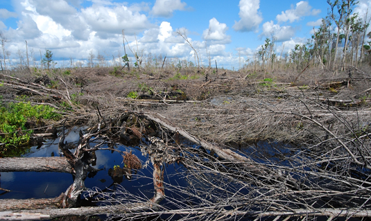
Burned peat swamp forest. Picture: Florian Siegert.
In the autumn of 2015, dense clouds of smoke filled the air for months over large areas of Southeast Asia, and in many places brought public life to a standstill. The reason for the thick pall of smoke was an extensive series of fires in the tropical peatlands of Indonesia, which many scientists are already calling a cataclysmic disaster. This year’s fires were particularly devastating because the current El Niño – a periodic global shift in weather patterns – has resulted in a long-term drought in the region. But even in a “normal” year, fires regularly destroy huge swathes of Indonesia’s forests and the thick layers of peat on which they grow. This results in the release of enormous amounts of greenhouse gases, in particular carbon dioxide (CO2), which have deleterious effects on global climate. In fact, as a result of this year’s fires, Indonesia became one of the largest emitters of greenhouse gases worldwide. “In order to work out precisely how much CO2 was generated by these forest fires, it is important not only to determine the size of the area affected, but also how much peatland was lost – and the latter parameter is very difficult to measure,” says Florian Siegert, Professor of Ecology at LMU and a specialist in remote-sensing techniques. “So far, very few data are available, and even these are not very informative. But in cooperation with colleagues at the University of Leicester, for the first time we were able to investigate in detail how far individual fires in certain parts of the region penetrated into the underlying soil layers. This allowed us to carry out a much more accurate analysis of the biomass lost than was hitherto possible, and our results show that the previous estimates have been too high.” The new results appear in the journal “Global Change Biology”.
Estimating the losses
Unlike the situation in Europe – where peat bogs are virtually treeless – a large fraction of Indonesia’s tropical forest rests on convex domes of peat up to 20 meters thick. Peat or turf is a precursor of coal and consists of strongly compressed plant material. As a consequence, it can store 10-50 times as much organic carbon as the forest that grows upon it. When the peat catches fire, much of this carbon is converted into the greenhouse gas CO2, raising its concentration in the atmosphere and promoting global warming. In undisturbed tropical forests, widespread fires are rare, simply because the substrate is too damp to sustain them. However, this picture changes dramatically when the ecological equilibrium is perturbed – by slash-and-burn clearance tactics and drainage projects, for instance. Particularly during climatically induced periods of drought – as typically the case for the region in El Niño years – extensive and long-lasting smoldering fires can occur, which are extremely difficult to bring under control.
In an area of 220,000 hectares located in Central Borneo, in which habitat degradation began in the 1990s with the onset of logging activities and the digging of several drainage canals, Siegert and his collaborators have carried out a fine-grained study of the extent of fire damage to the peat substratum. “The original intention was to grow rice on the cleared area. But the soil there is completely unsuitable for rice cultivation, and the crop was never cultivated. Hence, the area has lain fallow, and many fires have swept across it,” as Kristina Konecny, first author of the new study, explains. The researchers conducted an aerial survey of the area using a remote-sensing method known as LiDAR (Light Detection and Ranging). While conventional radar uses radio waves to gauge distances, LiDAR uses a laser that emits high-frequency light waves and records the reflected light “echoes”. In this way, surface topography can be determined with centimeter accuracy. By comparing the data with the height of the ground surface in areas that have not been affected by fire, it is then possible to model the original surface relief. The resulting difference map provides a three-dimensional picture of how much of the original peat substratum has been destroyed. “By combining these data with information about the incidence of fires in the area, for the first time we were able to reconstruct in detail its whole combustion history – and work out how much CO2 was released in each individual fire,” says Konecny.
Not all fires are equal
The team soon recognized that the amount of peat lost varied depending on the event considered, such that the volume of peat burnt fell as the number of fires at a given site increased. “This is because the supply of material that can reach combustion temperature is progressively diminished,” says Siegert. “The trees in the native forest are the first to go, and the fire can burn down into the roots, which extend deep into the peat. The wood that survived the first fire then fuels the next one, and by the fourth fire the vegetation consists only of grasses – which cannot sustain it for long.” The drainage canals also play a significant role. As a result of the withdrawal of ground water, the peat close to a canal is drier – which increases the risk of fire and probably allows the flames to penetrate deeper.
These findings have implications for attempts to estimate the magnitude of CO2 emissions that are attributable to the combustion of peatlands in the tropics. Siegert and his colleagues estimate that, in their study area, the first fire generated about 418 metric tons of CO2 per hectare. This drops to 48 tons per hectare for the fourth episode of fire. The figure for the first fire corresponds to 58%, while that for the fourth and subsequent fires is equivalent to only 7%, of the standard value assumed by the Intergovernmental Panel on Climate Change (IPCC). “Nevertheless,” Siegert emphasizes, “these fires are an unmitigated and completely senseless environmental disaster. The destruction of peatland in Indonesia this year alone generated some 1.8 gigatonnes of CO2. That is around twice the amount produced in Germany in a year,” he says. “We now hope that our more accurate measurements will be taken into account by the IPCC in the future, so that the quantification of greenhouse-gas emissions due to these forest fires can be improved. Precise and reliable assessments of emissions are also crucial for the operation of programs designed to reduce emissions with the aid of financial incentives – such as those agreed on at the UN Climate Conference in Paris.”
Kristina Konecny, Uwe Ballhorn, Peter Navratil, Juilson Jubanski, Susan E.Page, Kevin Tansey, Aljosja Hooijer, Ronald Vernimmen, Florian Siegert (2015) Variable carbon losses from recurrent fires in drained tropical peatlands. Global Change Biology. DOI: 10.1111/gcb.13186